2026
AWARE: Adaptive Whole-body Active Rotating Control for Enhanced LiDAR-Inertial Odometry under Human-in-the-Loop Interaction
Yizhe Zhang, Jianping Li†, Liangliang Yin, Zhen Dong, Bisheng Yang
Active Control & SLAM
ISPRS Journal of Photogrammetry and Remote Sensing (IF: 12.9), 2026
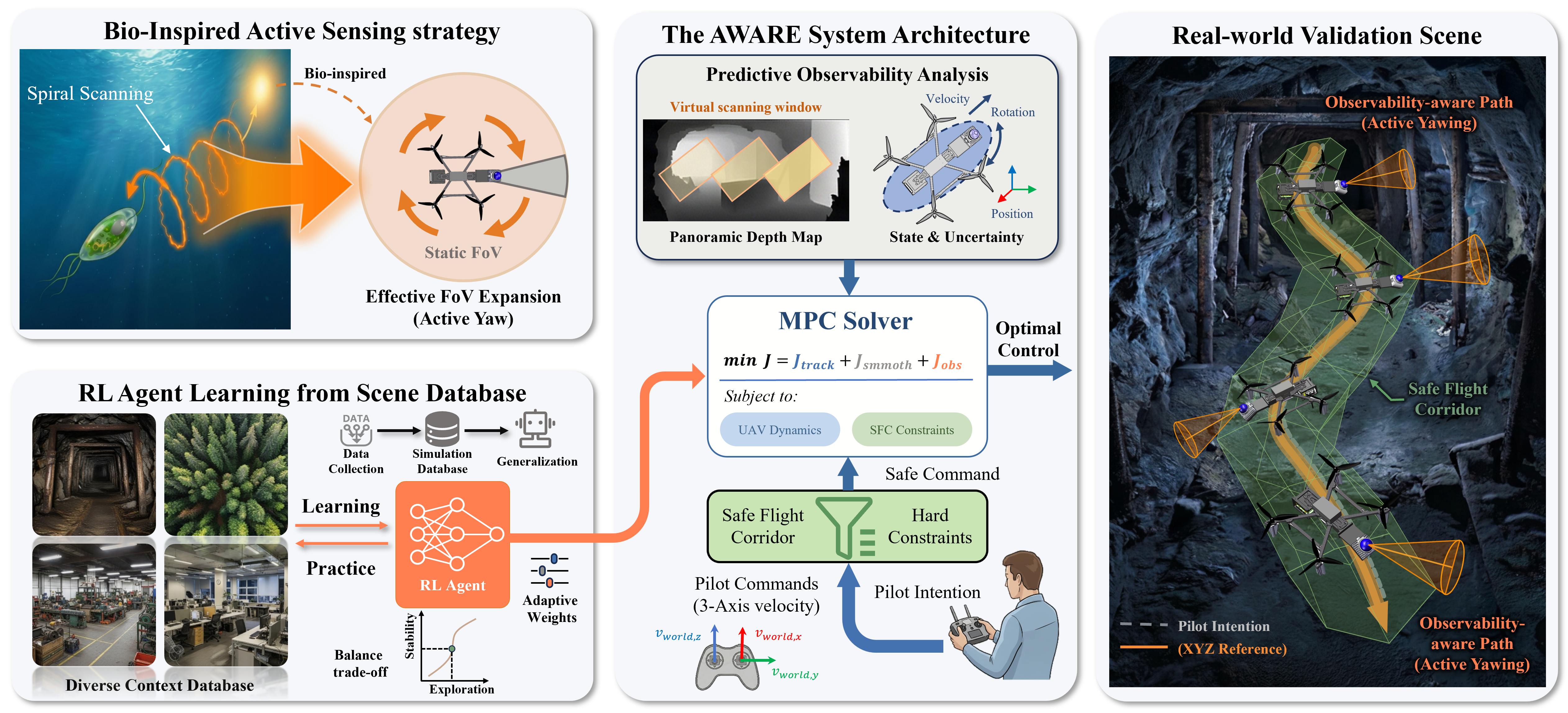
AWARE is a human-in-the-loop active control framework for improving LiDAR-inertial odometry on resource-constrained UAVs in feature-sparse environments. The key idea is to exploit whole-body yaw rotations through an RL-guided differentiable MPC controller, enabling the UAV to actively seek informative viewpoints while preserving flight safety and operator intent.
AWARE: Adaptive Whole-body Active Rotating Control for Enhanced LiDAR-Inertial Odometry under Human-in-the-Loop Interaction
Yizhe Zhang, Jianping Li†, Liangliang Yin, Zhen Dong, Bisheng Yang
Active Control & SLAM
ISPRS Journal of Photogrammetry and Remote Sensing (IF: 12.9), 2026
AWARE is a human-in-the-loop active control framework for improving LiDAR-inertial odometry on resource-constrained UAVs in feature-sparse environments. The key idea is to exploit whole-body yaw rotations through an RL-guided differentiable MPC controller, enabling the UAV to actively seek informative viewpoints while preserving flight safety and operator intent.
ARMOR: Adaptive meshing with reinforcement optimization of implicit fields for real-time 3D monitoring in unexposed scenes
Yizhe Zhang, Jianping Li†, Xin Zhao, Zhen Dong, Bisheng Yang
Adaptive Underground Meshing
ISPRS Journal of Photogrammetry and Remote Sensing (IF: 12.9), 2026
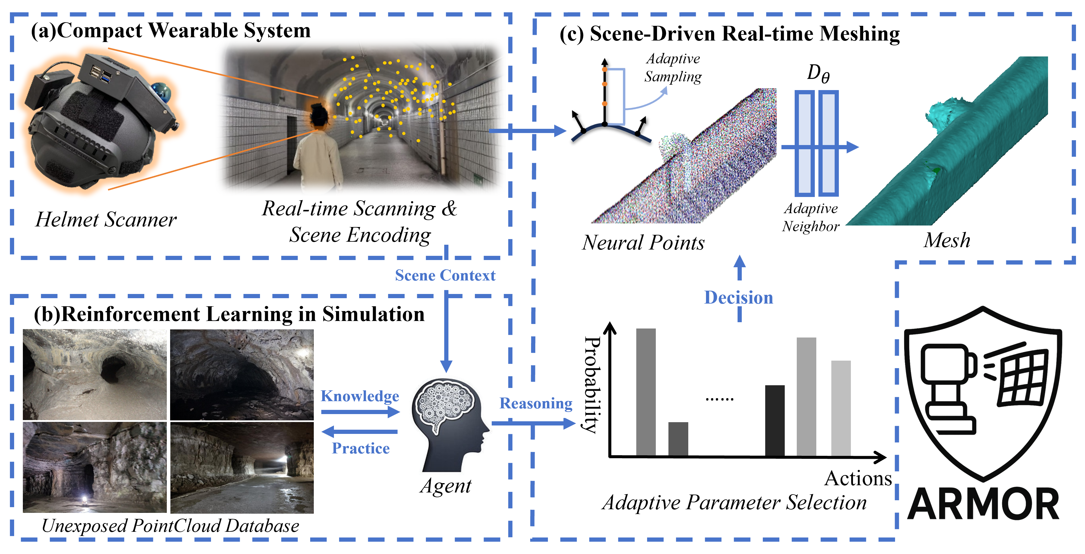
ARMOR is a scene-adaptive framework for real-time 3D meshing in unexposed environments such as tunnels, caves, and lava tubes. The key idea is to jointly optimize geometry reconstruction and parameter tuning with spatio-temporal smoothing and reinforcement learning, enabling robust online meshing under diverse and unstructured scene conditions.
ARMOR: Adaptive meshing with reinforcement optimization of implicit fields for real-time 3D monitoring in unexposed scenes
Yizhe Zhang, Jianping Li†, Xin Zhao, Zhen Dong, Bisheng Yang
Adaptive Underground Meshing
ISPRS Journal of Photogrammetry and Remote Sensing (IF: 12.9), 2026
ARMOR is a scene-adaptive framework for real-time 3D meshing in unexposed environments such as tunnels, caves, and lava tubes. The key idea is to jointly optimize geometry reconstruction and parameter tuning with spatio-temporal smoothing and reinforcement learning, enabling robust online meshing under diverse and unstructured scene conditions.
AGI2P: Benchmarking Aerial–Ground Image-to-Point cloud localization with a large-scale dataset
Yandi Yang, Jianping Li†, Youqi Liao, Yuhao Li, Ruizhe Niu, Yizhe Zhang, Zhen Dong, Bisheng Yang, Naser El-Sheimycc
Adaptive Underground Meshing
ISPRS Journal of Photogrammetry and Remote Sensing (IF: 12.9), 2026
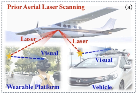
AGI2P is a large-scale benchmark for aerial–ground visual localization in dense urban environments, integrating ground-level mobile-mapping images with ALS point clouds from Wuhan, Hong Kong, and San Francisco (12 sequences, 69,000+ image–ALS pairs). The key idea is to use ALS as a scalable prior map and obtain accurate ground-truth poses via MLS-to-ALS alignment, enabling robust benchmarking of state-of-the-art I2P methods under challenging cross-view, cross-modal conditions.
AGI2P: Benchmarking Aerial–Ground Image-to-Point cloud localization with a large-scale dataset
Yandi Yang, Jianping Li†, Youqi Liao, Yuhao Li, Ruizhe Niu, Yizhe Zhang, Zhen Dong, Bisheng Yang, Naser El-Sheimycc
Adaptive Underground Meshing
ISPRS Journal of Photogrammetry and Remote Sensing (IF: 12.9), 2026
AGI2P is a large-scale benchmark for aerial–ground visual localization in dense urban environments, integrating ground-level mobile-mapping images with ALS point clouds from Wuhan, Hong Kong, and San Francisco (12 sequences, 69,000+ image–ALS pairs). The key idea is to use ALS as a scalable prior map and obtain accurate ground-truth poses via MLS-to-ALS alignment, enabling robust benchmarking of state-of-the-art I2P methods under challenging cross-view, cross-modal conditions.
2024
NeRF-based Localization and Meshing with Wearable Laser Scanning System: A Case Study in Underground Environment
Yizhe Zhang, Jianping Li†, Xin Zhao, Youqi Liao, Zhen Dong, Bisheng Yang
Underground Meshing
ISPRS Annals of the Photogrammetry, Remote Sensing and Spatial Information Sciences, 2024 Oral
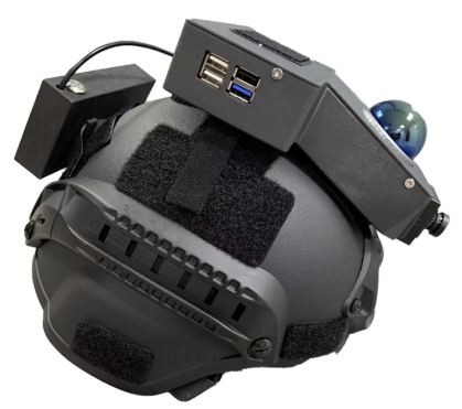
NeRF-based Localization and Meshing is a wearable framework for real-time localization and mesh reconstruction in complex underground environments. The key idea is to couple LiDAR-inertial odometry with a scan-block representation that synchronizes poses and sequential laser frames, enabling efficient NeRF-based meshing with improved local accuracy.
NeRF-based Localization and Meshing with Wearable Laser Scanning System: A Case Study in Underground Environment
Yizhe Zhang, Jianping Li†, Xin Zhao, Youqi Liao, Zhen Dong, Bisheng Yang
Underground Meshing
ISPRS Annals of the Photogrammetry, Remote Sensing and Spatial Information Sciences, 2024 Oral
NeRF-based Localization and Meshing is a wearable framework for real-time localization and mesh reconstruction in complex underground environments. The key idea is to couple LiDAR-inertial odometry with a scan-block representation that synchronizes poses and sequential laser frames, enabling efficient NeRF-based meshing with improved local accuracy.